 |
This is a file from the Wikimedia Commons. Information from its description page there is shown below.
Commons is a freely licensed media file repository. You can help.
|
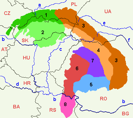
- Map of the main divisions of the Carpathian Mountains.
- Annotated version of image file Image:Mapcarpat.png
- Legend
Divisions of the Carpathians, in black numbers:
- 1, dark green: Outer Western Carpathians
- 2, light green: Inner Western Carpathians
- 3, dark orange: Outer Eastern Carpathians
- 4, light orange: Inner Eastern Carpathians
- 5, light blue: Southern Carpathians
- 6, red: Western Romanian Carpathians
- 7, purple: Transylvanian Plateau
- 8, pink: Serbian Carpathians
Rivers, in blue lower case letters:
- a: Vistula
- b: Danube
- c: Tisza
- d: Sava
- e: Dniester
- f: Prut
Countries (ISO 3166-1 alpha-2 codes), in red upper case letters:
- CZ: Czechia
- PL: Poland
- UA: Ukraine
- AT: Austria
- SK: Slovakia
- HU: Hungary
- RO: Romania
- HR: Croatia
- BA: Bosnia and Herzegovina
- RS: Serbia
- BG: Bulgaria
 |
Permission is granted to copy, distribute and/or modify this document under the terms of the GNU Free Documentation License, Version 1.2 or any later version published by the Free Software Foundation; with no Invariant Sections, no Front-Cover Texts, and no Back-Cover Texts. A copy of the license is included in the section entitled GNU Free Documentation License. http://www.gnu.org/copyleft/fdl.htmlGFDLGNU Free Documentation Licensetruetrue
|
File usage
The following pages on Schools Wikipedia link to this image (list may be incomplete):
Wikipedia for Schools is one of SOS Children's Villages' many educational projects. SOS Children believes that a decent childhood is essential to a happy, healthy. Our community work brings families new opportunities through education, healthcare and all manner of support. There are many ways to help with SOS Childrens Villages.


