
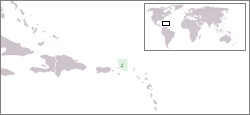
File:LocationBritishVirginIslands.png
LocationBritishVirginIslands.png (250 × 115 pixels, file size: 8 KB, MIME type: image/png)
| |
This is a file from the Wikimedia Commons. Information from its description page there is shown below.
Commons is a freely licensed media file repository. You can help. |
 |
File:LocationBritishVirginIslands.svg is a vector version of this file. It should be used in place of this raster image when superior. File:LocationBritishVirginIslands.png
For more information about vector graphics, read about Commons transition to SVG.
|
 |
- Description : Location map for British Virgin Islands
- Author : User:Vardion
Latina: Situs Britannicarum Virginearum Insularum
 |
This work has been released into the public domain by its author, Vardion at the English Wikipedia project. This applies worldwide. In case this is not legally possible: |
File usage
The following pages on Schools Wikipedia link to this image (list may be incomplete):
Learn more
Wikipedia for Schools was collected by SOS Children's Villages. SOS Children's Villages works in 133 countries and territories across the globe, helps more than 62,000 children, and reaches over 2 million people in total. There are many ways to help with SOS Children.