 |
This is a file from the Wikimedia Commons. Information from its description page there is shown below.
Commons is a freely licensed media file repository. You can help.
|
Summary
| DescriptionNaval Battle of Guadalcanal, November 14-15, 1942.png |
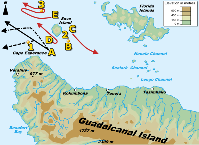
English: Chart of the second phase of the second night engagement of the Naval Battle of Guadalcanal, 23:30-02:00, November 14-15, 1942. Key:
- A- U.S. warship force: Washington (solid black line), South Dakota (large dotted line), and four destroyers (small dotted line is route of Gwin and Benham)
- B- Japanese destroyer Ayanami
- C- Japanese light cruiser Sendai and destroyers Uranami and Shikinami
- D- Japanese light cruiser Nagara and destroyers Shirayuki, Hastuyuki, Samidare, and Inazuma
- E- Japanese bombardment force: battleship Kirishima, heavy cruisers Atago and Takao, and destroyers Asagumo and Teruzuki
- 1- Location of sinking U.S. destroyers Preston and Walke
- 2- Location of sinking Japanese destroyer Ayanami
- 3- Location of sinking Japanese battleship Kirishima
Italiano: Mappa della seconda fase della seconda battaglia navale di Guadalcanal, 23:30-02:00, 14 e 15 novembre 1942. Legenda:
- A - corazzate USA Washington (linea nera intera), South Dakota (linea nera puntata) e quattro cacciatorpediniere (linea tratteggiata)
- B - cacciatorpediniere giapponese Ayanami
- C - incrociatore leggero giapponese Sendai e cacciatorpediniere Uranami e Shikinami
- D - incrociatore leggero giapponese Nagara e cacciatorpediniere Shirayuki, Hastuyuki, Samidare, e Inazuma
- E - forza da bombardamento giapponese: corazzata Kirishima, incrociatori pesanti Atago e Takao e cacciatorpediniere Asagumo e Teruzuki
- 1 - luogo dell'affondamento delle cacciatorpediniere statunitensi Preston e Walke
- 2 - luogo dell'affondamento del cacciatorpediniere giapponese Ayanami
- 3 - luogo dell'affondamento della corazzata giapponese Kirishima
|
| Date |
3 June 2011 |
| Source |
own work based on: GuadalcanalMap2.gif |
| Author |
Angelus (talk) |
Permission
( Reusing this file) |
I, the copyright holder of this work, hereby publish it under the following licenses:
 |
Permission is granted to copy, distribute and/or modify this document under the terms of the GNU Free Documentation License, Version 1.2 or any later version published by the Free Software Foundation; with no Invariant Sections, no Front-Cover Texts, and no Back-Cover Texts. A copy of the license is included in the section entitled GNU Free Documentation License. http://www.gnu.org/copyleft/fdl.htmlGFDLGNU Free Documentation Licensetruetrue
|
You may select the license of your choice.
|
|
This map was improved or created by the Wikigraphists of the Graphic Lab (it). You can propose images to clean up, improve, create or translate as well.
বাংলা | català | česky | Deutsch | Deutsch (Sie-Form) | Ελληνικά | English | Esperanto | español | suomi | français | עברית | magyar | Հայերեն | italiano | 한국어 | македонски | Bahasa Melayu | Plattdüütsch | Nederlands | occitan | polski | português | română | русский | slovenščina | svenska | татарча/tatarça | Türkçe | українська | 中文 | 中文(简体) | 中文(繁體) | Zazaki | +/−
File usage
The following pages on Schools Wikipedia link to this image (list may be incomplete):
Through Schools Wikipedia, SOS Children's Villages has brought learning to children around the world. In 133 nations around the world, SOS Children's Villages works to bring better education and healthcare to families in desperate need of support. Sponsoring a child is the coolest way to help.


