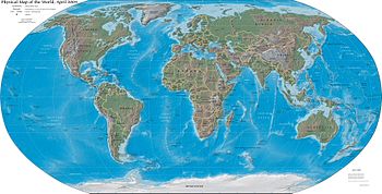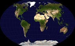
World map
Background to the schools Wikipedia
The articles in this Schools selection have been arranged by curriculum topic thanks to SOS Children volunteers. Visit the SOS Children website at http://www.soschildren.org/
A world map is a map of the surface of the Earth, which may be made using any of a number of different map projections.
Maps of the world are often either 'political' or 'physical'. The most important purpose of the political map is to show territorial borders; the purpose of the physical map is to show features of geography such as mountains, soil type or land use. Geological maps show not only the physical surface, but characteristics of the underlying rock, fault lines, and subsurface structures.
Projections
Maps that depict the surface of the Earth use a projection, a way of translating the three-dimensional real surface of the geoid to a two-dimensional picture. Perhaps the best-known world-map projection is the Mercator Projection, originally designed as a form of nautical chart.
Airplane pilots use aeronautical charts based on a Lambert conformal conic projection, in which a cone is laid over the section of the earth to be mapped. The cone intersects the sphere (the earth) at one or two parallels which are chosen as standard lines. This allows the pilots to plot a great circle (shortest distance) route approximation on a flat, two-dimensional chart.
Variations
Different from the world map used in Western Hemisphere, in East Asian countries, such as China, Japan and Korea, along with in Australia and New Zealand, another map is used which places American continents on the right, Europe and Africa on the left, and Asia-Pacific countries roughly on the centre.
Since Africa-centred maps give a rather strong distortion of North America, there are also maps that put America in the centre.
In Australia, reversed maps, with the south (and therefore Australia) at the top, are available, mainly for the tourist industry.


