Watling Street
Did you know...
SOS Children produced this website for schools as well as this video website about Africa. SOS Children has looked after children in Africa for forty years. Can you help their work in Africa?
Coordinates: 52°39′22.5″N 1°55′37.7″W
| Watling Street | |
|---|---|
 note: the westernmost segment, running south from Wroxeter, is not generally considered part of the Street; see text |
|
| Route information | |
| Length: | 276 mi (444 km) [230 mi (370 km) Rutupiae to Viroconium; 46 mi (74 km) Viroconium to Magnis] |
| Time period: | Roman Britain |
| Major junctions | |
| From: | Rutupiae / Dubris |
| Durovernum, Londinium, Verulamium, Durocobrivis, Magiovinium, Lactodurum, Bannaventa, Venonis, Manduessedum, Letocetum, Viroconium, Bravonium | |
| To: | Magnis |
Watling Street is the name given to an ancient trackway in England and Wales that was first used by the Britons mainly between the modern cities of Canterbury and St Albans. The Romans later paved the route, part of which is identified on the Antonine Itinerary as Iter III: "Item a Londinio ad portum Dubris" - from London to the port of Dover. Its route is now covered by the A2 road from Dover to London, and the A5 road from London to Wroxeter.
The name derives from the Old English Wæcelinga Stræt. Originally the word "street" simply meant a paved road (from Latin: "via strata"), and did not have the modern English-language association with populated areas.
History

British
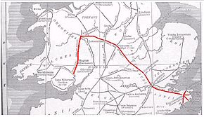
The Roman road followed the broad, grassy trackway already used by the Britons for many hundreds of years, although the newer road was made to follow a more direct course. It led from Richborough in the south-east by way of a ford of the Thames at present-day Westminster to near Wroxeter, where one section went on to Holyhead and another, by way of Chester, on towards Scotland.
Roman
A Roman road recorded in the Antonine Itinerary as "Iter III" linked London and Dover. The last section of the long Iter II route from Hadrian's Wall travelled through Viroconium (now Wroxeter in Shropshire), past Letocetum (modern day Wall) in Staffordshire, Manduessedum (modern day Mancetter - possible site of Boudica's last battle), Tripontium (modern day Newton and Biggin), Venonis (modern day High Cross) in Leicestershire, Bannaventa near Norton in modern-day Northamptonshire, Lactodurum (modern day Towcester - near another possible site of Boudica's last battle), then through Stony Stratford and Magiovinium ( Fenny Stratford) in modern-day Milton Keynes, Durocobrivis (modern day Dunstable) in Bedfordshire (where it crosses the even older Icknield Way), Verulamium (near modern-day St Albans in Hertfordshire) and London (by way of the ford at Thorney Island until London Bridge was finished, and the line of the modern Old Kent Road) to Rutupiae (now Richborough in Kent) on the southeast coast of England. While another section of Iter II linked Wroxeter to Chester, and other roads were built into north Wales and central Wales, these are not generally considered to be part of Watling Street. Thus the Roman routes which comprise Watling Street are all of Iter III and the middle-southern section of Iter II.
Main section
The main section of the road is that from Dover to Wroxeter. It was named Wæcelinga Stræt by the Anglo-Saxons, meaning "the paved road pertaining to the people of Wæcel". Wæcel could, possibly, be a variation of the Old English word Wealhas for 'foreigners' which was applied to the Celtic people inhabiting what is now Wales. This place-name element also gave us the name for Wæclingacaester (the early English name for Verulamium) and it seems likely that the road-name was originally applied first to the section between that town and London before being applied to the entire road.
A number of ancient names that contain the Old English element stræt testify to the ancient route of Watling Street: Boughton Street, Kent; Colney Street, Hertfordshire; Fenny Stratford and Stony Stratford in Buckinghamshire; Old Stratford in Northamptonshire; Stretton under Fosse and Stretton Baskerville, both in Warwickshire; the three adjacent settlements of All Stretton, Church Stretton and Little Stretton in Shropshire; and Stretton Sugwas, Herefordshire.
Subsidiary routes
Stone Street ran southeast for some 12 miles from Watling Street at Canterbury (the Roman Durovernum) to Lympne (Lemanis) at the western edge of the Romney Marsh. Most of it is now the current B2068 road that runs from the M20 motorway to Canterbury.
Another Stone Street from Magnis (Kenchester) in modern Herefordshire to Caerleon, Isca Augusta and the main Roman legionary base in the south of Roman Wales.
Battle of Watling Street
Part of the route was the site of the Roman victory at the Battle of Watling Street in 61 AD between the Roman governor Gaius Suetonius Paulinus and the Briton leader Boudica.
Danelaw
In the 9th century, Watling Street was used as the demarcation line between the Anglo-Saxon and Danish-ruled parts of England. The Treaty of Wedmore required the defeated Danes to withdraw to an area north and east of Watling Street, thus establishing the Danelaw.
Chaucer's Pilgrims
Like most of the Roman road network, the Roman paving fell into disrepair when the Romans left Britain, although the route continued to be used for centuries afterwards. It is likely that Chaucer's pilgrims used Watling Street to travel from Southwark to Canterbury in his Canterbury Tales.
Turnpike
The road north of London became a Turnpike firstly in 1707 when the section from Fourne hill north of Hockliffe to Stony Stratford was paved following an Act of Parliament on March 4, 1707.
This was the first Turnpike Trust and showed how financially hazardous the undertaking could be.
The Fourne hill to Stony Stratford case provides more evidence that Parliament would void undertakers’ rights if they were negligent. The trustees for the Fourne hill to Stony Stratford road borrowed more than 7000 pounds in 1707 and 1708 to improve the road. The creditors, however, claim to have been misinformed regarding the expected revenues from the tolls, and requested in 1709 that a new act extend the term and increase the tolls. A new act was passed in 1709 extending the term, but the tolls were not increased. It also included a provision that the creditors could take receivership of the tolls if the trustees had not repaid their debts by 1711. Apparently, the trustees were unable to borrow and the creditors took over the tolls. In 1716, Parliament tried to clarify the situation by passing an act that vested authority in the trustees from the 1709 act and another group appointed by the Justices of the Peace for Buckinghamshire. The 1716 act was not amended for its entire term of 23 years, but once it was set to expire, Parliament decided that it would not renew the rights of the existing trustees for the Fourne hill to Stony Stratford road. In 1736, the trustees submitted a petition for an extension of their rights, but it failed to pass and in 1739 their authority ended. In 1740, a new act was passed naming a replacement body of trustees. In the petition for the new bill, the inhabitants of Buckinghamshire described the road as being ‘ruined.’ This sentiment was affirmed by the Member heading the committee for the bill.
The road was re-paved in the early 19th century by Thomas Telford who brought it back into use as a turnpike road for use by mail coaches bringing mail to and from Ireland, his road being extended to the port of Holyhead on the Isle of Anglesey in Wales. At this time the section south of London became known as the Great Dover Road. The toll system ended in 1875.
Modern road
Most of the road is still in use today, apart from a few sections where it has been diverted. The stretch of the road between London and Dover is today known as the A2, and the stretch between London and Shrewsbury is today known as the A5 (which now continues to Holyhead). The sections of the road which pass through Central London are known by a variety of names, including Edgware Road and Maida Vale. At Blackheath the Roman road ran along Old Dover Road, then turning and running through Greenwich Park to head to a location perhaps a little north of the existing Deptford Bridge. Through Milton Keynes, the A5 is diverted onto a new dual carriageway and Watling Street forms part of the new town's grid system and carries the additional designation V4.
Continued use of the name along the ancient road
The use of the street name is retained along the ancient road in many places: for instance, in Bexleyheath in Southeast London and on into Kent (including the towns of Canterbury, Gillingham, Strood, Gravesend and Dartford). Also, in London, a major road joining the A5 in north west London is called Watling Avenue. North of London, the name Watling Street still occurs in Hertfordshire (including St Albans), Bedfordshire, Buckinghamshire (including Milton Keynes), Northamptonshire (including Towcester), Leicestershire, Warwickshire (including Nuneaton), Staffordshire (including Cannock, Wall, Tamworth and Lichfield), Shropshire (including in Church Stretton as the residential Watling St North and South) and Gwynedd.

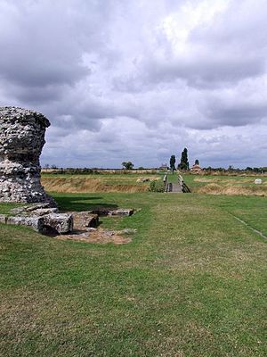
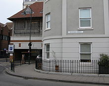
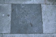
A section of Watling Street still exists in the City of London close to Mansion House underground station on the route of the original Roman road which traversed the River Thames via the first London Bridge and ran through the City in a straight line from London Bridge to Newgate.
Other Watling Streets
The Roman Road from Cataractonium (now Catterick, North Yorkshire) to Corstopitum (now Corbridge, Northumberland) and on to the Antonine Wall (also known as Grym's Dyke or Graham's Dyke, from Grim, a name of Woden ) also came to be known as Watling Street, with perhaps a similar Old English etymology owing to its path into the foreign land of Scotland. This route is also known as Dere Street. This may also be the case for another Watling Street in Lancashire, which runs from Manchester ( Mamucium) via Affetside to Ribchester ( Bremetennacum), and hence ultimately led to another 'foreign land' in Saxon times, that of Rheged or modern Cumbria.
A Watling Street Road exists to this day in the city of Preston, Lancashire. It connects the districts of Ribbleton and Fulwood and passes the site of Sharoe Green Hospital.


