Geography of Namibia
Background to the schools Wikipedia
SOS Children made this Wikipedia selection alongside other schools resources. With SOS Children you can choose to sponsor children in over a hundred countries
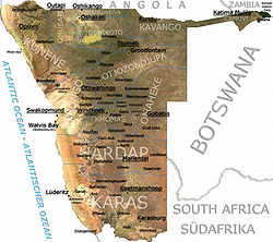
At 825,418 km2 (318,696 sq mi), Namibia is the world's thirty-fourth largest country (after Venezuela). After Mongolia, Namibia is the least densely populated country in the world (2.5 inhabitants per square kilometre (6.5 /sq mi)).
Climate
Desert; hot, dry; rainfall sparse and erratic
| Climate data for Namibia | |||||||||||||
|---|---|---|---|---|---|---|---|---|---|---|---|---|---|
| Month | Jan | Feb | Mar | Apr | May | Jun | Jul | Aug | Sep | Oct | Nov | Dec | Year |
| Source: ???? | |||||||||||||
Statistics
Location: Southern Africa, bordering the South Atlantic Ocean, between Angola and South Africa
Geographic coordinates: 22°00′S 17°00′E
Map references: Africa
Area:
total: 825 418 km²
land: 825 418 km²
water: 0 km²
Land boundaries:
total: 3 824 km
border countries: Angola 1 376 km, Botswana 1 360 km, South Africa 855 km, Zambia 233 km
Coastline: 1 572 km
Maritime claims:
contiguous zone: 24 nmi (44.4 km; 27.6 mi)
exclusive economic zone: 200 nmi (370.4 km; 230.2 mi)
territorial sea: 12 nmi (22.2 km; 13.8 mi)
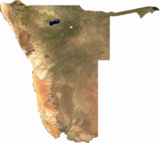
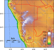
Terrain: Mostly high plateau; Namib Desert along coast; Kalahari Desert in east. In the north near the border with Angola there is a flat area that has been designated by the World Wildlife Fund as part of the Angolan Mopane woodlands ecoregion.
Elevation extremes:
lowest point: Atlantic Ocean 0 m
highest point: Königstein 2 573 m
Natural resources: diamonds, copper, uranium, gold, lead, tin, lithium, cadmium, zinc, salt, vanadium, natural gas, hydropower, fish
note: suspected deposits of oil, coal, and iron ore
Land use:
arable land: 0.99% (1998 est.) 1% (1993 est.)
permanent crops: 0% (1998, 1993 est.)
permanent pastures: 46% (1993 est.)
forests and woodland: 22% (1993 est.)
other: 99.01 (1998 est.), 31% (1993 est.)
Irrigated land: 70 km² (1998 est.), 60 km² (1993 est.)
Natural hazards: prolonged periods of drought
Environment - current issues: very limited natural freshwater resources; desertification
Environment - international agreements:
party to: Antarctic-Marine Living Resources, Biodiversity, Climate Change, Desertification, Endangered Species, Hazardous Wastes, Law of the Sea, Ozone Layer Protection, Wetlands
signed, but not ratified: none of the selected agreements


