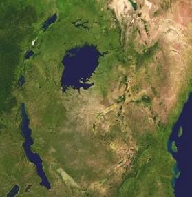
African Great Lakes
Background Information
SOS Children made this Wikipedia selection alongside other schools resources. See http://www.soschildren.org/sponsor-a-child to find out about child sponsorship.

The Great Lakes of Africa are a series of lakes in and around the geographic Great Rift Valley formed by the action of the tectonic East African Rift. They include Lake Victoria, the second largest fresh water lake in the world in terms of surface area, and Lake Tanganyika, the world's second largest in volume as well as the second deepest. The term Greater Lakes is also used, less commonly, for some of them.
The Great Lakes are divided among three different catchments (river basins), and a number, such as Lake Turkana have internal drainage systems. The following, in order of size from largest to smallest, are included on most lists of the African Great Lakes:
- Lake Victoria
- Lake Tanganyika
- Lake Nyasa
- Lake Turkana
- Lake Albert
- Lake Kivu
Some call only Lake Victoria, Lake Albert, and Lake Edward the Great Lakes, as they are the only three that empty into the White Nile. Lake Kyoga is part of Great Lakes system, but is not itself considered a Great Lake, on size grounds. Lake Tanganyika and Lake Kivu both empty into the Congo River system, while Lake Malawi is drained by the Shire River into the Zambezi. Lake Turkana has no outlet.
Two other lakes close to Lake Tanganyika do not appear on the lists despite being larger than Edward and Kivu: Lake Rukwa and Lake Mweru.
Because the term is a loose one, it is often preferable to use other categorizations such as African Rift Valley Lakes or East African Lakes.
Great Lakes region
The term Great Lake region is likewise somewhat loose. It is used in a narrow sense for the area lying between northern Lake Tanganyika, western Lake Victoria, and lakes Kivu, Edward and Albert. This comprises Burundi, Rwanda, north-eastern DR Congo, Uganda and north-western Kenya and Tanzania. It is used in a wider sense to extend to all of Kenya and Tanzania, but not usually as far south as Zambia, Malawi and Mozambique nor as far north as Ethiopia, though these four countries border one of the Great Lakes.
An estimated 107 million people live in the Great Lakes region.. The area described in the narrow sense above is one of the most densely populated areas of Africa. Because of past volcanic activity this area also contains some of Africa's best farmland. Its altitude gives it a sub-tropical climate despite being right on the equator, becoming temperate in the mountains. This makes tropical diseases of humans and livestock, such as trypanosomiasis, less prevalent, so that, for instance, cattle and other susceptible animals thrive.
Because of the density of population and the agricultural surplus in the region the area became highly organized into a number of small states. The most powerful of these monarchies were Rwanda, Burundi, Buganda, and Bunyoro. Unusually for sub-Saharan Africa, the traditional borders were largely maintained by the colonial powers.
Being the long sought after source of the Nile, the region had long been of interest to Europeans. The first Europeans to arrive in the region in any numbers were missionaries who had limited success in converting the locals, but did open the region to later colonization. The increased contact with the rest of the world led to a series of devastating epidemics affecting both humans and livestock. These decreased the region's population dramatically, by up to 60% in some areas. The region did not return to its precolonial population until the 1950s.
While seen as a region with great potential after independence, the region has in recent decades been marred by civil war and conflict, from which only Tanzania has largely escaped. The worst affected areas have been left in great poverty.

